How are mountain bike trails rated?
MTB trail difficulty ratings are generally based upon 6 parameters:
surface features
Gradient (level of steepness)
Trail width
Natural obstacles
Technical features
Fitness level
It should be noted that fitness level is not used in all trail rating systems, such as the IMBA of Canada and the United States of America
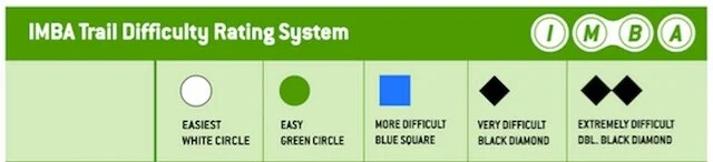
The International Mountain Bicycling Association (IMBA) created a Trail Difficulty Rating System (TDRS) in 2008 and is used in North America. The TDRS has 5 distinct grading levels and most trail rating systems around the globe are based upon or adapted from the IMBA’s trail rating system.
The Trail Difficulty Rating System (TDRS) only focuses on rating the technical challenge of trails and is not focused on physical fitness, or physiological challenges. Most trails are posted with signs indicating the length, which allows the rider to access their level of physical fitness or biking stamina.

White Circle: Very Easy (Easiest)
Fire-road or wide singletrack
Flat and smooth that is free of obstacles
However, is most likely a multi-use trail and frequent encounters with other cyclists, hikers, walkers, and horse riders are common
(Image Source: eBike Shed Ltd)

Green Circle: Easy:
Fire road becomes a fire-path or wide singletrack
Gentle gradient, but smooth surface free of obstacles


Blue Square: More difficult/Intermediate:
Most likely a singletrack trail with moderate gradients
Some surface variables and small obstacles


Black Diamond: Very difficult:
Challenging singletrack with steep gradients
Surface features and variable trail obstacles are frequent


Double Black Diamond: Extremely difficult:
Steep gradients
Highly variable surface features
Unavoidable and severe obstacles

The IMBA mountain bike trail rating system and the European singletrack trail rating systems are adapted from the National Ski Areas Association (NSAA) difficulty of terrain ratings, which is used in ski areas throughout the world. To understand the MTB rating system, first, we need to understand the NSAA rating system. After a brief history, I will explain each of the distinct categories of the MTB trail difficulty rating systems.
trail ratings of ski areas

The first official ski resort in North America opened to the public in 1936 in Sun Valley, Idaho and by 1966 there were 662 ski areas. During this time there were no trail ratings or uniformity among ski areas for terrain variations.
“The rating symbols were originally developed by The Walt Disney Company”
“The purpose of this standardization was to make ski resorts a safer place by advertising a universally understood system on the map and on the mountain.
The rating symbols were originally developed by The Walt Disney Company, which was planning to build a Disney themed ski resort in Mineral King, California.”
-Amy Elizabeth Lippus
The Disney Company never did build the resort, however, these carefully designed symbols were adopted by the National Ski Areas Association (NSAA) in 1968 and are in use today by hundreds of ski areas across the United States and Canada.
mountain bike trail ratings broken down by category
The Trail Difficulty and Rating System (TDRS) by the IMBA is based on four main parameters:
Trail width - Average width of the bike path or singletrack trail
Tread (trail) surface - Material and stability of the trail. Is the trail a paved bike path (hardened)? Other trail surface terms include firm, stable, variable, widely variable, loose and unpredictable.
Trail gradient
Maximum grade: Steepest section of the trail
Average grade: Steepness of trail over its entire length. Total elevation gain of trail is divided by trail length and turned into a percentage.
Natural obstacles (OB) and Technical Trail Features (TTF) - Rocks, roots, logs, ledges, drop-offs, holes are all examples. Some TTF are added for an increased technical challenge, such as elevated bridges and teeter-totters. The height of each obstacle is measured, with greater heights indicating a higher level of difficulty
When these four parameters are combined they provide a single indication of trail difficulty. The TDRS does not account for trail length and physical exertion of the trail.
TRAIL WIDTH
The IMBA trail width ranking ranges from 6 inches (150 mm) to over 72 inches (1,800 mm).
1. Easiest (White Circle): Over 72 inches (1,800mm)
Two riders can ride side by side
2. Easy (Green Circle): 36 inches (900 mm) to 71 inches
Shoulder width or greater
3. Intermediate (Blue Square) 24 inches (600 mm) to 35 inches
Handlebar width or greater
4. Challenging (Black Diamond) 12 inches (300 mm) to 23 inches
Sections that are more narrow than the handlebars
5. Advanced (Double Black Diamond) 6 inches (300 mm) to 11 inches
Longer sections and with a greater frequency of sections that are narrower than the handlebars

This trail is an easy double track - enough room for side by side riding
The narrower the section the more handling skill is needed by the MTB rider to keep the bike on the trail.
Some very narrow sections will be walked by less technically advanced riders on Black Diamond & Double Black Diamond trails.
TRAIL (TREAD) SURFACE
Material and stability of the trail, which is on a continuum from pavement to unstable surfaces and everything in-between.
1. Easiest : Hardened surfaces
Paved or blacktopped paths
2. Easy: Firm and stable surface
Smooth gravel trail/road
Farm road or fire road
3. Intermediate: Mostly stable, but with some sections of rocky and loose tread
Smooth singletrack
Flow-style trail
4. Challenging: Mostly variable
Many sections of rocks, roots, which creates unstable and variable riding surfaces
5. Advanced: Widely variable and unpredictable
Larger rocks, roots, logs and create widely variable and unpredictable surface conditions

Smooth gravel combined with rocks
Average Trail Gradient & MTB Difficulty Rating

trail gradient
White Circle (easiest): Fairly flat with mild climbs and descents.
Average grade = <5%
Maximum grade = Max 10%
Green Circle (easy): Average gradient is similar to WHITE CIRCLE rides, but this trail may include a modest steep section(s).
Average grade = 5% or less
Maximum grade = Max 15%
Blue Square (intermediate): This trail has a modest overall level of steepness with some sections that are very steep, with most riders walking their MTB.
Average grade = 10% or less
Maximum grade = 15% or greater
Black Diamond (difficult): Maximum grade is the same as the intermediate level trail, but average grade is higher due to sections of steeper descents and climbs.
Average grade = 15% or less
Maximum grade = 15% or greater
Double Black Diamond (advanced): Prolonged steep climbs and descents
Average grade = 20% plus
Maximum grade = 15% or greater
All gradient numbers are sourced from the IMBA website and TDRS chart.

About a Blue Square level of steepness
Natural obstacles & Technical Features
Natural obstacles and technical trail features (TTF) include rocks, roots, logs, ledges, drop-offs, elevated bridges, and teeter-totters. Some TTF’s are added for increased riding challenges and enjoyment. There is also a distinction between unavoidable and avoidable objects, with the following info referencing unavoidable natural obstacles:
White Circle - None. Zero natural obstacles or TTF are present on the biking trail
Green Circle - 2 inches (50 mm) tall or less
Small rocks, roots and fallen branches
Blue Square - 8 inches (200 mm) tall or less
Unavoidable bridges could be present on intermediate trails and paths
Obstacles such as logs, rocks, and roots
More challenging features might be present but are avoidable
Black Diamond - 15 inches (380 mm) or less
Numerous unavoidable obstacles such as logs, rocks, drop-offs & rock gardens
Artificial obstacles may be present such as jumps, bridges, teeter-totter, etc.
The majority of obstacles are unavoidable
Off-camber sections (outside edge of the track is lower than the inside edge)
Double Black Diamond - 15 inches (380 mm) or less (same as single black diamond)
Same as Black Diamond, but includes more obstacles, with greater variety and frequency. Also, these features are UNAVOIDABLE
Numerous off-camber sections

This is a Blue Square trail - Some trail obstacles but mostly flow-esque mtb trail
How is the height of the obstacle measured?
The height is measured from the trail (tread) surface to the top of the obstacle. Uneven heights are measured up to a point where it’s the easiest to ride over.
Climb Easier: Pedaling Science all-season lube

Regional differences
Trails should be related relative to other trails in the region, and trails will rate differently from region to region.
A blue square trail in one region might be a black diamond trail someplace else. A blue square in Moab is going to rank as a black diamond in many other regions in the United States.
If the local chapter of the IMBA is competent, then local ratings will be consistent among trails of that specific area.
MTBA in Australia
Mountain Bike Australia (MTBA) adapted the IMBA Trail Difficulty Rating System. Instead of providing numbers, such as gradient percentages, trail width, and obstacle height the MTBA rating system gives a description.
Also, this modified rating system includes a fitness level ranging from “most people in good health” to higher levels of fitness.” The IMBA doesn’t provide levels of physical exertion due to the subjective nature of this classification.
European mtb ratings
Many European countries also adapted there ski area trail ratings along with additional input and alterations from the IMBA’s trail ratings. Thus green, blue, red and black symbols, which match the ski area symbols. Orange is often used to indicate bike park or freeride terrain.

General MTB grades from Forestry and Land Scotland .gov. scot
It’s important to note that the many countries that use the European MTB rating system use two separate rating systems. The first type is for general MTB riding such as biking on paved bike path, while the second rating system is specific to singletrack trails.
The second system uses 6 singletrack rating grades and is called the Single Track Scale (STS).
S0 - Very easy. Minimal gradient and wide huge turns like forest road. No special skill is needed
S1 - Easy. Small obstacles, such as flat roots and small rocks. Slight gradient with no tight turns and basic level of riding skill
S2 - Intermediate. Larger roots and rocks with normal steps and stairs and wide hairpin curves. Controlled braking and body weight shifting skills are used
S3 - Difficult. Rocks become boulder, large roots, high steps and loose terrain, tricky with steep sections. More advanced riding skills needed, such as precise braking and rider balance.
S4 - Very Difficult. Trails with large boulders, roots, loose terrain with very tight turns with steps that can cause chainring to hit ground. Advanced riding techniques needed
S5 - Extremely Difficult. Boulder fields with counter-ascents, debris, landslides, tight hairpin turns, repeated sections with fallen trees, all while riding very steep terrain with short passages for accelerating and braking.


Jesse (Director of Pedal Chile) lives in Chile’s Patagonia..most of the year. Jesse has a Master of Science in Health and Human Performance and is an avid snowboarder and MTB rider. Hobbies: reading, writing, sampling craft beer and riding singletrack trails in Chile.


Sources:
https://www.imba.com. (n.d.). Trail Difficulty Rating System | IMBA. [online] Available at: https://www.imba.com/resource/trail-difficulty-rating-system
forestryandland.gov.scot. (n.d.). Trail grades - Forestry and Land Scotland. [online] Available at: https://forestryandland.gov.scot/visit/activities/mountain-biking/mountain-biking-trail-grades
IMBA Australia Trail Difficulty Rating System 2013. (n.d.). [online] Available at: https://www.mtba.org.au/wp-content/themes/mtba/images/imba/downloads/IMBA_Australia_Trail_Difficulty_Rating_System_2013_Web.pdf
Lippus, Amy Elizabeth, "The History and Evolution of North American Ski Resort Map Style and Design" (2015). Graduate Student Theses, Dissertations, & Professional Papers. 4518.
Trail Difficulty Rating System – IMBA Canada. Available at: https://imbacanada.com/trail-difficulty-rating-system/
Steyn WJV, Van Niekerk H, Jacobs WMG. Classification of mountain bike trails using vehicle-pavement interaction principles. S Afr J Res Sport Phys Educ R. 2014;36(1):211-27. link