
According to the Köppen Climate Classification system, South America is comprised of 3 main climate types by land area, with 60.1% of the continent classified as tropical, which is the most of any continent.
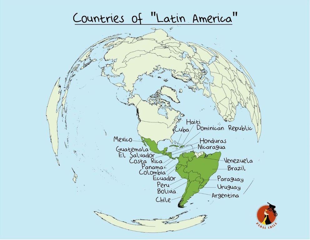
However, neither Chile, Uruguay, nor Argentina is in the tropical zone.
Uruguay and Argentina contain regions of subtropical, similar climatic conditions to those of the southern USA and Europe.
Climatic Zones of South America
Climatic Zones of South America: By Percentage

Lu in Puerto Natales, Chile
Tropical Climate Defined
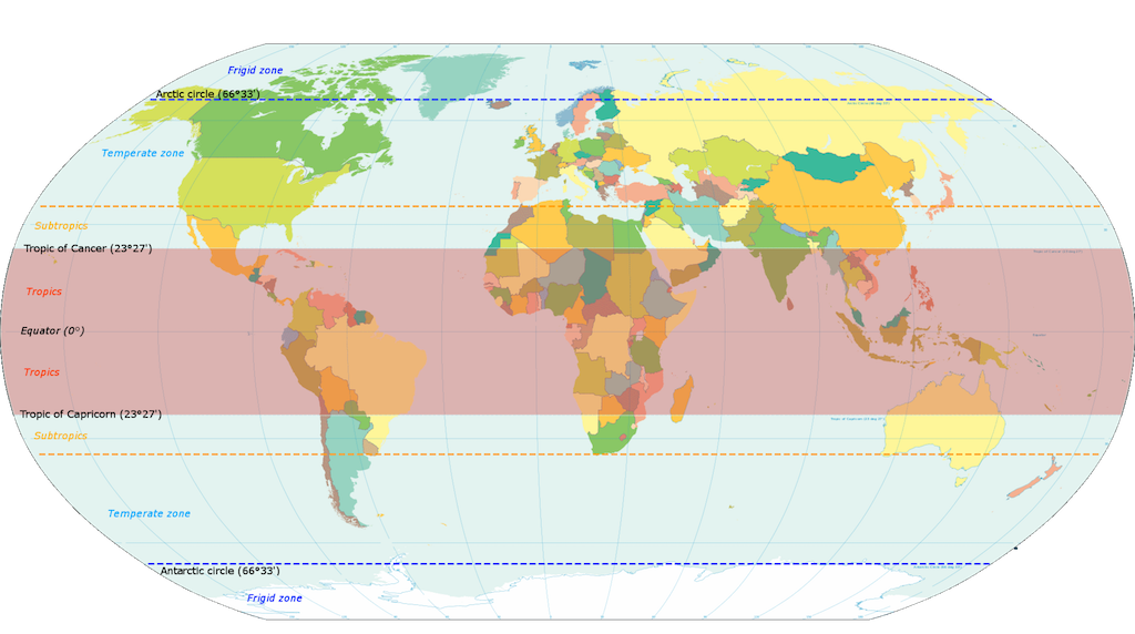
Earth’s tropical zone lies between the Tropic of Cancer and the Tropic of Capricorn. The tropics are warm year-round, averaging 77°F to 82°F (25 to 28°C).
However, just because a region is located in the tropical zone doesn’t automatically qualify it as tropical. High-elevation mountainous areas, for example, are located throughout the tropics, yet the climate in these regions is anything but hot and humid.
According to the Köppen climate classification system, tropical climates must have a monthly average temperature of 64.4℉ (18℃) or higher year-round. This means that the average air temperature of ALL months must be warmer than 64℉ (18℃) to be classified as tropical.
South American Countries Tropical Area
Although the majority of South America’s environment can easily be classed as tropical, parts of the continent are not. As one ventures further south into southern Brazil, Paraguay, Uruguay, Argentina, and Chile, the climate becomes progressively sub-tropical, temperate, and even significantly cold.
Perito Moreno Glacier, Argentina (Patagonia)
Drier environments also become far more frequent. Southern Brazil, Paraguay, and northern Argentina have a rather sub-tropical climate – although seasons typically found in many temperate climates occur in this region, summers are often long and rather warm, whereas winters are generally mild, with frosts occurring on a rare basis.
Large areas of grassland cover the east of this region, with pockets of woodland occurring in places. However, the climate becomes drier the further west one travels – northern Argentina, for example, has a steppe-type environment.

The Salar de Uyuni in Bolivia - (World’s largest salt flat)
Much of central and southern Argentina contains a temperate and colder environment, with rainfall levels decreasing the further south one travels. Both northern and central Argentina are covered in extensive steppe environments, with temperate woodlands rarely found. Southern Argentina and the south-eastern tip of Chile are referred to as Patagonia – this is a semi-arid plateau located between the Andes Mountains and the Atlantic Ocean. With a rather dry and cold environment (winters are rather long the further south one travel), this part of South America is in stark contrast to the vast tropical rainforests and grasslands found to the north.
The Andes Mountains span a vast length of South America. The range stretches along the western side of the continent, from its far southern tip up to Colombia and Venezuela in the north. As expected, it traverses a wide range of different environments and has its own mountainous climate driven by its high altitude.

Pico Cristóbal Colón. The highest peak in Colombia (Image Source: Olsen)
The southern and south-western coast of Chile is rather cold, with heavy snowfall producing a heavily glaciated landscape. Large glaciers calve their way through the mountains to the Pacific Ocean. Much of the Patagonian Andes are rather cold and snowy, with large areas of beech forest covering the valleys within the mountain range.
Many areas between the Andes and the Pacific, located south of 38° latitude, are covered in dense temperate oceanic forests. However, both the Andes and the region immediately to their west become increasingly drier the further northwards one travel. The mountains themselves retain their cold temperature and dryness but become more tropical in climate as they venture into Peru, and remain that way until their demise.

Valle De La Luna, II Región, Chile (Valley of the Moon in Chile’s Atacama desert)
However, there is one last distinctive non-tropical climate of South America – the Atacama Desert. Covering much of northern Chile, and extending into south-western Bolivia, the Atacama is an incredibly hyper-arid region, some of which is considered to be the driest place on Earth. With a completely barren landscape filled with rocks and sand and a temperature that is comparatively low compared to similar latitudes elsewhere, this landscape is incredibly different from the vast tropical regions found on much of South America.
Although the coastal regions of the Atacama Desert can be rather warm (particularly in December, January, and February), the dry western sides of the Andes Mountains can be rather cold, particularly in the winter months.
5 Main Climate Types

A) Tropical B) Arid (desert/dry) C) Temperate D) Cold E) Polar
Tropics area by Continent

Valentina is a guide for Pedal Chile and is our resident badass. Valentina was born and raised in La Patagonia, which probably explains her affinity for adventuring. When Valentina isn’t crushing some poor dude’s soul, you can find her shredding down Rucapillán. Favorite season: Austral Summer
More articles from Pedal Chile


References & Sources for “Is South America Tropical?”
Beck, Christoph & Grieser, Jürgen & Kottek, Markus & Rubel, Franz & Rudolf, B.. (2005). Characterizing Global Climate Change by means of Köppen climate classification.
Belda, M, et al. “Climate Classification Revisited: From Köppen to Trewartha.” Climate Research, vol. 59, no. 1, 4 Feb. 2014, pp. 1–13, pdfs.semanticscholar.org/a82b/1659b079d412e006f9de49e17aca9014b982.pdf, 10.3354/cr01204.
“Chapter 42. South America: Ecological Zones.” Www.fao.org, www.fao.org/3/y1997e/y1997e1b.htm.
“File:Tropical Climate (Köppen Climate Classification).Svg - Wikimedia Commons.” Wikimedia.org, 20 Feb. 2016, commons.wikimedia.org/wiki/File:Tropical_climate_(K%C3%B6ppen_climate_classification).svg. (figure 1)
Olsen, Bryant. “Pico Cristóbal Colón.” Flickr, 2 Feb. 2017, www.flickr.com/photos/bryanto/32621470492.
Peel, M. C., et al. “Updated World Map of the Köppen-Geiger Climate Classification.” Hydrology and Earth System Sciences, vol. 11, no. 5, 11 Oct. 2007, pp. 1633–1644, 10.5194/hess-11-1633-2007.
Schipper, Jan. “Atlantic Coast Restingas.” One Earth, www.oneearth.org/ecoregions/atlantic-coast-restingas/.
Schipper, Jan. “Eastern South America: Eastern Coast of Brazil | Ecoregions | WWF.” World Wildlife Fund, www.worldwildlife.org/ecoregions/nt0144.
The Editors of Encyclopedia Britannica. “Amazon Rainforest | Plants, Animals, Climate, & Deforestation.” Encyclopædia Britannica, 23 Oct. 2017, www.britannica.com/place/Amazon-Rainforest.
“Tropics.” Wikipedia, 9 Mar. 2021, en.wikipedia.org/wiki/Tropics#/media/File:World_map_indicating_tropics_and_subtropics.png.